


Voting District 10285, Contra Costa County, California
About
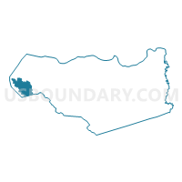
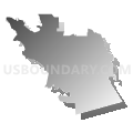
Outline

Summary
| Unique Area Identifier | 529750 |
| Name | Voting District 10285 |
| County | Contra Costa County |
| State | California |
| Area (square miles) | 17.83 |
| Land Area (square miles) | 14.57 |
| Water Area (square miles) | 3.25 |
| % of Land Area | 81.76 |
| % of Water Area | 18.24 |
| Latitude of the Internal Point | 37.92873610 |
| Longtitude of the Internal Point | -122.36349160 |
Maps


Graphs
Select a template below for downloading or customizing gragh for Voting District 10285, Contra Costa County, California


Neighbors
Neighoring Voting District (by Name) Neighboring Voting District on the Map
- Voting District 10090, Contra Costa County, CA
- Voting District 10105, Contra Costa County, CA
- Voting District 10120, Contra Costa County, CA
- Voting District 10235, Contra Costa County, CA
- Voting District 10250, Contra Costa County, CA
- Voting District 10255, Contra Costa County, CA
- Voting District 10256, Contra Costa County, CA
- Voting District 10260, Contra Costa County, CA
- Voting District 10280, Contra Costa County, CA
- Voting District 10286, Contra Costa County, CA
- Voting District 10290, Contra Costa County, CA
- Voting District 10315, Contra Costa County, CA
- Voting District 10325, Contra Costa County, CA
- Voting District 51595, Alameda County, CA
- Voting District BAY, Alameda County, CA
- Voting District BAY, Contra Costa County, CA
Top 10 Neighboring County Subdivision (by Population) Neighboring County Subdivision on the Map
Top 10 Neighboring Place (by Population) Neighboring Place on the Map
- Richmond city, CA (103,701)
- San Pablo city, CA (29,139)
- El Cerrito city, CA (23,549)
- Albany city, CA (18,539)
- North Richmond CDP, CA (3,717)
Top 10 Neighboring Unified School District (by Population) Neighboring Unified School District on the Map
- West Contra Costa Unified School District, CA (235,847)
- Albany City Unified School District, CA (18,549)
Top 10 Neighboring State Legislative District Lower Chamber (by Population) Neighboring State Legislative District Lower Chamber on the Map
Top 10 Neighboring State Legislative District Upper Chamber (by Population) Neighboring State Legislative District Upper Chamber on the Map
Top 10 Neighboring 111th Congressional District (by Population) Neighboring 111th Congressional District on the Map
- Congressional District 10, CA (714,750)
- Congressional District 7, CA (655,708)
- Congressional District 9, CA (648,766)
Top 10 Neighboring Census Tract (by Population) Neighboring Census Tract on the Map
- Census Tract 3720, Contra Costa County, CA (7,353)
- Census Tract 3820, Contra Costa County, CA (6,964)
- Census Tract 3770, Contra Costa County, CA (6,962)
- Census Tract 3690.01, Contra Costa County, CA (6,246)
- Census Tract 3790, Contra Costa County, CA (6,117)
- Census Tract 3810, Contra Costa County, CA (6,097)
- Census Tract 3760, Contra Costa County, CA (5,962)
- Census Tract 3800, Contra Costa County, CA (5,706)
- Census Tract 3650.02, Contra Costa County, CA (5,462)
- Census Tract 3680.01, Contra Costa County, CA (5,327)
Top 10 Neighboring 5-Digit ZIP Code Tabulation Area (by Population) Neighboring 5-Digit ZIP Code Tabulation Area on the Map
- 94806, CA (59,861)
- 94804, CA (38,559)
- 94801, CA (29,395)
- 94530, CA (23,877)
- 94805, CA (13,648)
- 94710, CA (6,948)
- 94850, CA (0)